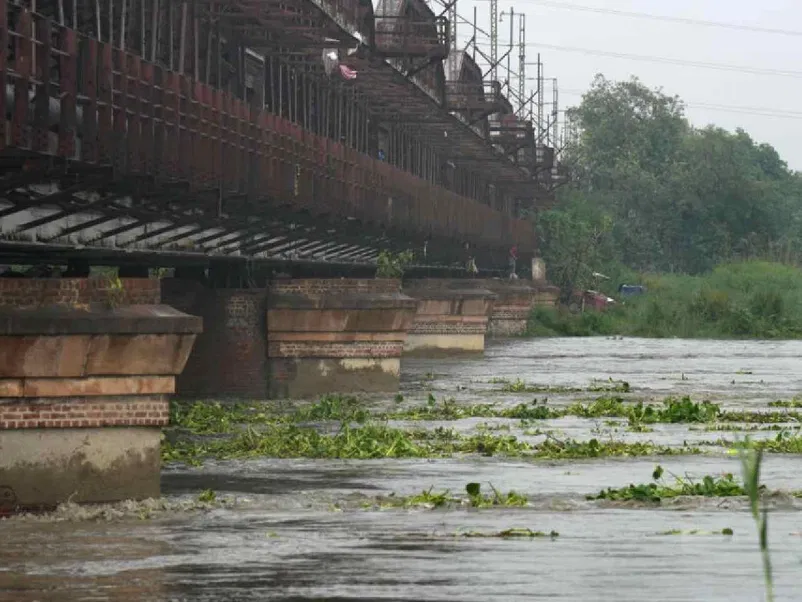
Three barrages and 26 bridges cut across the floodplains in a 22 km stretch, inhibiting the river flow.
Yamuna river reached the highest-ever mark in Delhi and caused a flood panic. (Photo credit: PTI)
New Delhi: Did you know that the National Capital Territory of Delhi has as many as 26 bridges and three barrages on Yamuna in the 22 km stretch between Wazirabad and Okhla barrages? Adding to that, there are only about 6,300 hectare (Ha) of active floodplains out of the total 9,700 Ha, with the rest consumed by development.
So, on Wednesday, when the Yamuna river reached the highest-ever mark in Delhi and caused a flood panic, environmental activists stated that the water discharged from Hathnikund barrage in Haryana must not be solely blamed. The fragmentation of the Yamuna floodplains in the national capital is also adding to the flood fury.
Heavy rainfall battering northern India has resulted in overflowing rivers, loss of lives and property damage. Since Sunday, July 9, Haryana has been releasing large quantities of water into the Yamuna which led to flooding in Delhi.
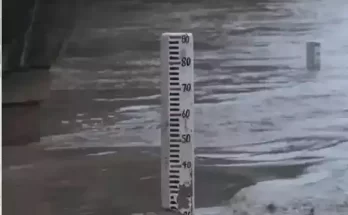
On Wednesday, the water level in Yamuna rose to 207.55 m, 2.22 m above the danger mark (205.33 m) and 0.06 m above its previous high flood level (HFL) on September 6, 1978. The Central Water Commission (CWC) described it as “Extreme Flood Situation”.
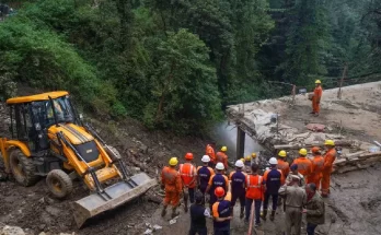
Delhi government set up around 2,500 camps in six districts for the people displaced by the floods. Indian Railways diverted all trains from the Old Loha Pul railway bridge since Monday, July 10. The Irrigation and Flood Control Department deployed boats for surveillance and rescue.
Fragmented Yamuna floodplains
As per the Delhi Development Authority’s (DDA) notification for Masterplan 2041, the Yamuna is considered the ‘O’ zone and is spread over 9,700 Ha, measuring 52 km from Palla where it enters Delhi to Jaitpur village where it leaves Delhi.
The DDA document also shows that out of the 9,700 Ha, the River Zone i.e. active floodplain is merely 6,295 Ha and the Riverfront i.e. the regulated area is 3,638.36 Ha.
There is no exact data about the extent of official, unofficial, organised and authorised or unauthorised encroachment of the floodplains. But environmental activists say that approximately 1,000 Ha may be covered by concrete structures.
These include Delhi Secretariat (although not shown on the floodplain), Akshardham temple, Commonwealth Games Village, Yamuna Bank Metro Station and depot, Akshardham Metro station and the residential colony nearby, Shastri Park Metro Station and depot, etc.
There are three barrages on Yamuna – at Wazirabad, ITO, and Okhla. Then, there are all the bridges and their approach roads built on the floodplains.
Considering the different set of pillars for each of the bridges as a single span, there are as many as 26 bridges cutting across Yamuna between Wazirabad barrage and Okhla barrage. This includes 17 road bridges, two rail bridges, and four Delhi Metro bridges, apart from three under-construction bridges.
Till about 100 years ago, Yamuna flowed freely in Delhi. The Ring Road along the river today was part of the floodplains. The portion of the Ring Road between the Red Fort and the Salimgarh Fort was in fact a channel of the river.
Delhi-based politician Ramvir Singh Bidhuri, 70, still remembers how the Yamuna was unfettered till the 1970s. “Every year, after the monsoon, there would be vast tracts of sand along the Yamuna banks. We would go there to play. The farmland of Jaitpur village (part of his constituency now) was parallel to the Yamuna Khadar.”
“There was a kuchcha bund wall built by the Britishers along both sides of the river. If I remember correctly, it was in the 1970s that we had the worst flood till then. Only after that the kuchcha bund was turned into a reinforced embankment,” Bidhuri adds.
Another long-time Delhi resident, Paras Tyagi recalls how the villages upstream of Wazirabad used to be exposed to Yamuna floods regularly. “In 1977, Yamuna gobbled up the aabadi areas of Fatehpur Jat village. And the floods cut across Sunderpur Shahdara (on the east) and Sunderpur Delhi. It wiped out the Sunderpur Delhi village, which now has just vast open floodplains in non-monsoon season.”
Tyagi, who runs the Centre for Youth, Culture, Law and Environment (CYCLE), an NGO working for the development of 360 villages of Delhi, says that the pushta or the embankment near Jagatpur (upstream of Wazirabad barrage) was built then.
But after the 1970s, the Yamuna floodplains started facing rapid encroachment by unauthorised colonies. Even the government took over a large portion of the floodplains for constructing Players’ Building ahead of the 1982 Asian Games. The building now houses Delhi Secretariat.
Damage due to floodplain fragmentation
Environment experts are worried about the impact of these encroachments on the river ecology.
“The 22 km stretch between Wazirabad barrage and Okhla barrage has three barrages and 26 bridges for roads, railways, metro and Regional Rapid Transit System or RRTS. The multiple bridges have fragmented the floodplains and affected the spread of flood water during monsoon,” says Bhim Singh Rawat, associate researcher, South Asia Network on Dams, Rivers and People (SANDRP).
The damage does not stop there.
All of Delhi’s bridges are meant to have a span of 500 m to allow 12,000 cubic metres per second flow of water below it.
While the actual bridges meet the 500 m rule, the approach roads to the bridges are also built on the floodplains, aligned perpendicular to the flow of the river, extending the effective span impacting the river.
“These bridges facilitate official, illegal encroachments of the riverbed vis-a-vis creation of approach roads and guide bunds to protect the bridge structures, grabbing of large floodplain area in lieu of space for maintenance facilities and dumping of construction material. These, too, result in negative impact on the river ecosystem,” Rawat adds.
Manu Bhatnagar, Director, Natural Heritage Division at the non-profit Indian National Trust for Art and Cultural Heritage (INTACH), explains how sediment flow is affected due to the barrages. “When the flood starts to recede and water flow slows down, sediment will settle down. The mere presence of the barrage and the fact that in non-monsoon months only one or two gates release water means that sandbars form near the barrage, particularly downstream.”
For instance, both at ITO barrage and Okhla barrage, the gates towards the right bank are open and the sandbars form near the left. Bhatnagar adds, “The sandbars narrow down the Yamuna channel further.”
Government knows everything, does nothing
The Flood and Irrigation Department had come up with a Flood Level Map of Delhi based on 2011 flood levels. The map clearly shows how Delhi has eaten into the floodplains. In fact, as late as 2019, Delhi government had allotted a 45 acre plot in the Yamuna floodplains for a plant to process construction and demolition waste.
Multiple activists had filed petitions with the National Green Tribunal. They drew attention to the unwarranted activities on the floodplains as against the recommendations of the Expert Committee to develop water bodies on the floodplains.
Late environmentalist Anupam Mishra had warned, “In the span of a river’s life, 75, 100, or 150 years are a mere fraction. It is now allowing stupid humans to play in her courtyard. But a day will come when Yamuna will claim her ground and, you never know, might reach Vijay Chowk, too.”
Is Delhi ready for such an eventuality?
(This story first appeared on news9live.com on Jul 12, 2023 and can be read here.)